A series of storm systems this week will usher in the return of a snowfall threat for southern New England. Significant Snow does not appear to be the most likely scenario for Connecticut, but only a small westward shift in the forecast track is needed for that to happen.
Discussion:
Upper Level: A trough is intensifying on the Southeast Coast today while a northern stream upper level low moves into the great lakes region by Tonight. Around here, Some weak ridging has set up which will begin to retreat. The shortwave kicks out to our south and east on the leading edge of this larger trough. The Trough will persist through at least midweek.

Surface: Intense low pressure off the coast of South Carolina tracks northeast then east northeast passing well offshore to our southeast tomorrow. A clipper system approaches New England from the great lakes region where a secondary coastal low may develop off the mid-atlantic coast and then track east. An inverted trough may continue to interact will the area as the low pulls away.

**An extended period of snow is expected for southern New England**
The greatest probability of significant snow exists in far eastern new England as a powerful offshore cyclone works to draw significantly colder air southward into New England. This will enhance precipitation on Monday and bring strong winds into much of Southeastern Massachusetts and Rhode Island. Light snow is possible again Monday night into Tuesday as well as Tuesday into Wednesday with the aformentioned succeeding waves of low pressure.
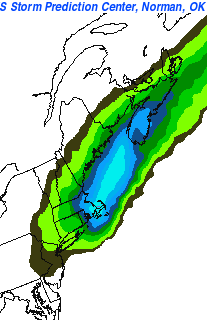 The SREF Ensemble mean does Heavily Favor eastern New England with the upcoming storm as does much of the other guidance. It will be important to monitor the eventual track of the surface low in real time because a minor shift could bring heavier snowfall totals into eastern Connecticut.
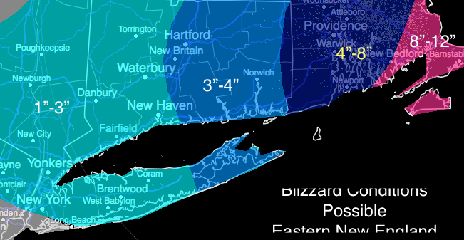
Here’s my Official Map For the Connecticut Area for the Monday Storm:

Leave a comment