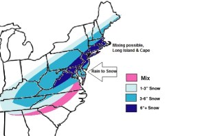
When it comes to this month, it will be remembered for snow as many cities and towns in the northeast will be breaking all time records for January snowfall. This impressive winter just continues to pound. To be honest, I like the snow map I had from this weekend, I think it is very close to what the actual total is, but I am issued a revised version of it to include more of the south, and to factor in a now consistent eastward shift we have seen in the models. I am still going with the 6+ figure as the highest category because I think the jack pot for this storm in the snowiest areas is not going to get much higher than a foot as an average. Also, the other piece of energy I had coming across the Ohio Valley is south of where I had it on my previous map and totals are adjusted to accommodate that as well.
1. The deep cold air that was in place at the beginning of the week is gone, as a result snow ratios will be low (on the order of 10:1 – 12:1).
2. Coastal areas and I am still adamant on this will start off with rain or mixed precipitation, amounts will be highly dependent on how quick that changeover occurs, which is a factor of the storm track and the intensity.
3. This will be a quick event and at any one location you will likely see the snow taper off within 12 hours of the start time.
until then…

Leave a comment