Category: Uncategorized
-
Five Day Outlook (8/19 through 8/23)
Discussion: A positive tilted 500mb trough will linger in the eastern half of the country for the next couple days. Some areas of low pressure will try to develop along a quasi-stationary frontal boundary at the surface in connection with this trough. This could bring some unsettled weather into the…
-
Outlook for the Next Few Days (8/10/2012 – 8/14/2012)
Discussion: A complex low pressure system will affect southern New England during the day on Friday and Saturday. A slow moving frontal boundary to the west will make our area a focal point for a couple rounds of intense showers and thunderstorms. Gusty Winds, flash flooding and dangerous lightning are…
-
Analyzing Today’s severe weather Threat
Main Limiting Factors weaker convergence due to slower progression of surface cold front light low level winds uncertainty with the amount of marine influence Forecast Graphic:
-
Potential For a Major Severe Weather Outbreak Tomorrow
An upper level trough has stalled near the Canadian maritime, while a frontal boundary just to our north at the surface will become the focus for some severe development tomorrow. I’m particularly concerned about tomorrow across our area because of the amount of low level moisture available. When you through…
-
Tracking Some Thunderstorms in the Area today
Some storms are moving across the area as some upper level energy has provided fuel for that warm and humid air mass at the surface to convect. The atmosphere here in Connecticut is generally characteristic of a 1500-2000 j/kg MUCAPE airmass. Damaging winds and even some hail cannot be ruled…
-
Heatwave Number 4 for NYC Metro, Parts of Southern New England
Surface high pressure is in control over much of the eastern seaboard. Towards the second half of the weekend, an upper level shortwave trough will swing through the northeast from the great lakes. A strengthening ridge over the central US will gain influence toward the beginning of the workweek. Very…
-
Thursday’s Weather Summary 5/30/2012
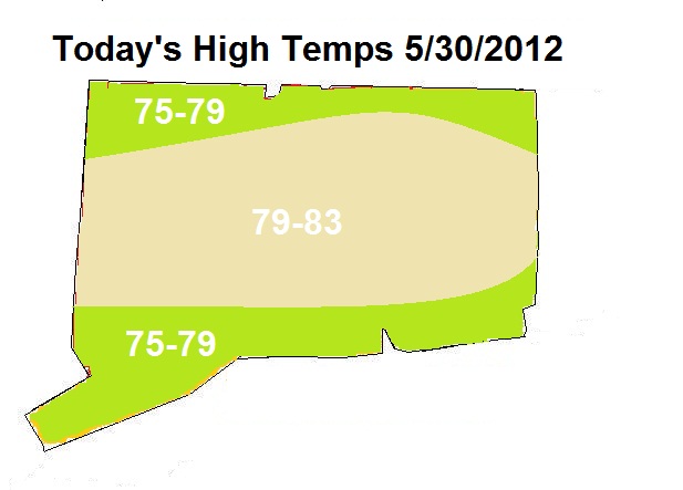
The Cold Front is still trailing well behind that original line of storms from yesterday across parts of northern and western New England. The Cloudiness associated with the remnants of that line remains over much of the eastern part of the region. You can see our surface dewpoints here in…
-
Saturday’s Forecast
Discussion: An upper level trough over New England and a surface low to the east has been the source of a brisk Northwest flow that will continue to keep temperatures cool into the weekend. The trough will gradually lose its influence as we head into the beginning of next week.…