Category: Forecasts
-
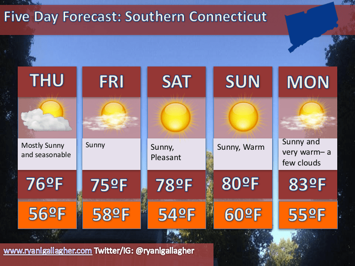
6/18 Forecast
Discussion:High pressure will remain in control through early next week. Low pressure off the coast of florida drifts northward and passes well east of the area while a cold front approaches from the west on Tuesday. Scattered thunderstorms, a few of which may reach severe limits, will be a factor on…
-
6/17: Evening Forecast Update
Discussion: A couple waves of low pressure lie along a frontal boundary draped across the Carolinas. Here in the northeast, High Pressure is in control and should remain in place into early next week. It slowly departs south and east with an approaching cold front late on Tuesday. Behind the front, high…
-
6/17: Forecast Update
Discussion: A frontal boundary in the mid atlantic has pushed into the Carolinas as a cold front. High Pressure continues to build in from the north and should remain in place through the weekend. An approaching cold front arrives late on Tuesday, behind which high pressure will return. An upper level…
-
June 16, 2016 – Evening Update
Discussion: A frontal boundary lies across the mid atlantic region along which an area of low pressure will develop and track, passing well to our south and west. Clouds tonight and into tomorrow will give way to clearing as the day progresses. An easterly breeze should keep coastal areas cool…
-
6/16/2016 Forecast Discussion
A warm front sits to our south. Out ahead of it cloud cover and showers have overspread the region. Expect some clearing this afternoon but clouds will stick around tonight and into tomorrow as an area of low pressure slips to our south and west. High pressure starts to build in from…
-
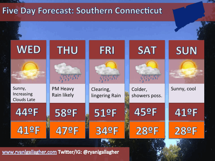
6/15/2016 Forecast Briefing
Discussion: A dry weekend in tap. Above normal temperatures return for the 2nd half of the weekend.
-
A Sunny Return
A temporary end of the rainy period has arrived, and fittingly is began during the second half of mother’s day. Most of May to this point has been characterized by rain, cloudiness and cool temperatures. Last week we collected around an inch and a half of rain This compensates in…
-
Unsettled Weather heading into this weekend, turning colder.
Rain develops today, and lingers into the evening. A generally unsettled pattern this weekend means cold temperatures and the possibility of snow on Saturday. Milder weather for early next week but more unsettled weather also approaches.
-
Stormy Thursday/Friday Followed by a Cold Weekend
Discussion: An unsettled weather pattern late this week will bring rain, large swings in temperature and a couple more opportunities for crop killing freezes this weekend.
-
Crop Threatening Cold Shots in the Northeast this week
Discussion: Surface: High pressure moves in for Wednesday and departs to our east on Thursday. A clipper system approaches Friday, pulling a cold front through for the weekend. Upper Levels: Some ridging builds in through Wednesday. A deepening trough kicks in during the second half of the week and remains in…
