Category: Uncategorized
-
Coldest Air of the Season to hit Tuesday and Wednesday
Major height falls happen through tonight as a powerful arctic airmass plunges into the region. Through mid afternoon tomorrow we are looking at some significant positive vorticity advection in the upper levels, which is a good diagnostic for upward motion when this advection increases with height. It’s one of the…
-
Coldest Air of the Season to hit next week, then leave.
A highly amplified pattern develops in the beginning of next week to start off the New Year. After a relatively mild weekend, temperatures will plunge late Monday and into Tuesday to levels we have not seen since last winter. Widespread single digits and teens will be the story. Having said…
-
The White Christmas Dilemma – 12/20/2011 update
Not much has changed since the previous writeup I did before exams kicked in. We still have had a significant lack in the mechanisms that drive cold air into the eastern US and as a result a persistent zonal flow that has locked the coldest air up to the north.…
-
Long Range, AO Breakdown? Where are the Temps Going?
A lot of questions are arising about the state of the winter going into the mid-late December time period. We’ve been locked into a patten that has kept much of the cold air locked up in Canada with more of a zonal North Atlantic Jet, and a zonal to even…
-
Weather Discussion – Dec. 8, 2011
Zonal 500 MB flow in the east, and a big ridge out off the pacific northwest are the major players right now. That storm that brought all the unsettled weather in the last 36 hours is a monster over Canada. According to the HPC analysis the storm deepened explosively from…
-
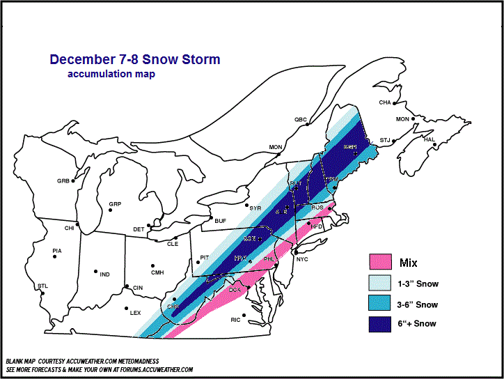
December 7th Evening Snow Update
No Major changes to my map.. I just wanted to point out the progression of the temperature field using the latest surface obs map. Much more widespread area of low 30’s. 50s still hanging on in eastern zones. I drew out a rough contour of it myself.
-
Snow Update December 7, 2011
Here’s what we are looking at in terms of the frontal boundary, I was saying yesterday that the position of this is critical to where the storm lines itself up:
-
Northeast Snow probabilities
At 22 UTC, 6 December 2011, KOKX was reporting light rain with a temperature of 56F. A stationary front was located across the interior northeast stretching all the way down the Appalachians into Central Alabama. Aloft, a 500mb shortwave trough is positively tilted from Michigan to western Texas. Moist southerly…
-
Erie, PA Weather Discussion – 12/5/2011
at 16:00 UTC, 5 December 2011 – KERI was reporting temperatures around 48F with rain in the area. A surface cold front is approaching the area and bringing with it some cloud cover and precipitation. Out east of it, deep layered southwesterly flow is prevalent as a positively tilted upper…
-
Thanksgiving Week Forecast
Discussion: Zonal upper level flow will remain with us for the next few days. By Wednesday an area of higher potential vorticity associated with an upper level shortwave will approach from the west. A surface low connected with this will track over or very close to the region and bring…
